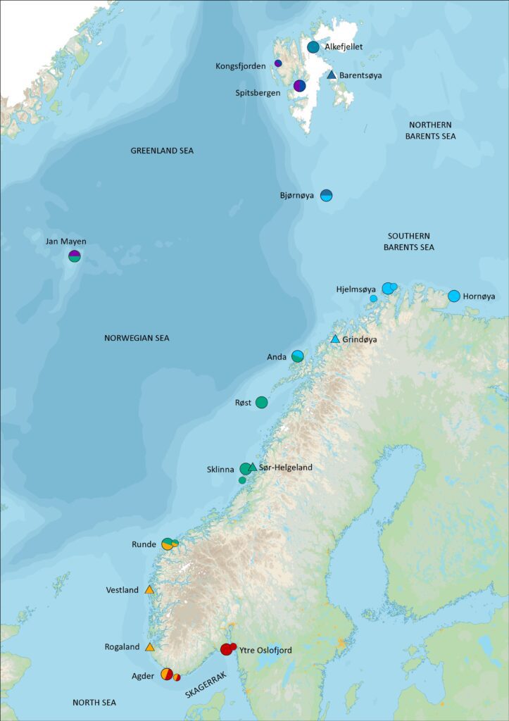
Key sites in SEAPOP
Seabird monitoring is the most resource-demanding task in SEAPOP and encompasses annual registrations of population size, adult survival, reproduction and diet for a selection of so-called “key species” from a geographical selection of localities.
The sites reflect variation
The aim is to reflect the ecological variation in the seabird communities in an adequately nuanced manner. Out of consideration for cost efficiency and logistics, a large part of this monitoring effort is distributed over a small number of “key sites”. SEAPOP monitoring encompasses just under 20 such species and localities, and more than 50 people in total participate in this work in the most hectic field period in June-July. The monitoring is carried out following well-established, international standards. The results are essential for analyses that can explain changes in the seabird populations, and are also used to calibrate the mapping data to produce estimates that match expectations for actual population sizes.
SEAPOP’s key sites are distributed around Norway, from Spitsbergen in the north to Agder in the south, and from Jan Mayen in the west to Hornøya in the east. Here you will find a description of the different key sites:
Spitsbergen, Svalbard
Bjørnøya, Svalbard
Hornøya, Finnmark
Hjelmsøya, Finnmark
Grindøya, Troms
Anda, Nordland
Røst, Nordland
Sklinna, Trøndelag
Runde, Møre og Romsdal
Ytre Oslofjord
Demanding work
Traditionally, population monitoring has mainly focussed on documenting changes in numbers. This gives necessary indications as to which development trends deserve special attention, but cannot alone explain the reasons for the changes observed. If one is to discover these reasons and make reliable prognoses, one must additionally monitor the reproduction rates, adult survival rates and preferably also diet, at the same localities. This is the main purpose of the work conducted at the key sites. A combination of several conditions explains why this activity is particularly demanding:
Species variation – ecological selection of species
Different species in the ecosystem can react differently to climate changes at one locality alone, usually because they depend on different food sources. A change in climate can, e.g., favour certain species, but disfavour others. The seabirds’ food availability can thus also change in equally different ways. Therefore, in order to reflect the most important changes, one must monitor a selection of species that are representative, from an ecological point of view, of the composition of the regional seabird community.
Geographical variation – ecological selection of sites
Different prey species have different distributions, and as actors in different food chains they can react completely differently to the same changes in the environment. Therefore, one seabird species that primarily lives off of one particular prey species in one area can experience completely different conditions for reproduction and survival than the same species does at other places where it lives off of other prey. This helps to explain why the development in seabird populations is not the same everywhere and why one must therefore monitor several geographical populations of the same species to achieve a representative picture. In SEAPOP, we aim to monitor the populations at 3-5 key sites within each of the five naturally delimited sea areas, which can be considered as different ecosystems. From south to north these are defined as Skagerrak (the Swedish border – Lindesnes), the North Sea (Lindesnes – Stad), the Norwegian Sea (Stad – Vesterålen), the southern Barents Sea (Troms and Finnmark) and the northern Barents Sea (Svalbard). To cover the northeastern arctic part of the Norwegian Sea that borders the Greenland Sea, we also established a key locality on Jan Mayen in 2010. To cover an adequate selection of species, the monitoring efforts at some of the key sites are divided between several geographically separated colonies. For example, on Spitsbergen the work is conducted both in Isfjorden and Kongsfjorden. This is still described as one key site, because the results collectively fulfill SEAPOP’s intended definition of the term “key site”.
The first key sites in SEAPOP were established in the Lofoten – Barents Sea area in 2004-2005, while the ones further south were first up and running in 2008. The work in the north benefitted from the fact that annual studies for three of the sites were in place several decades before SEAPOP, and could further build upon a foundation of time series from Røst (from 1964), Hornøya (from 1980) and Bear Island (from 1986). In the south there were almost only series for population development, but the studies on European shag reproduction on Sklinna (from 1980) and lesser black-backed gull and European herring gull survival in Vest-Agder (from 2000) were important exceptions.
Long breeding season and large individual variation
Seabirds use a long time to complete a breeding season. Brooding often takes a month or more, and the young generally take an even longer time to fledge. In addition, there is often large individual variation in the timing of egg laying. The time of breeding, breeding success, survival and diet can all vary sizably. The sample size that is studied must therefore be large enough that the data series reflects the real variation within the population in a statistically adequate manner. If too few individuals are studied, one will likely receive a skewed picture of what is actually happening. It can often take 3-4 months from when the first pairs lay eggs until the last young have left the colony, and one must collect data throughout large parts of this period to obtain representative material.

Photo © Magdalene Langset